![](/images/other/stat-length.png)
![Randonnée Marche Les Baux-de-Provence - Les amants - Maussane les Alpilles - Photo](https://media.geolcdn.com/t/1900/400/ext.pjpeg?maxdim=2&url=https%3A%2F%2Fservices.sitytrail.com%2FGeolivesWS%2FDownloadMedia.ashx%3FTrailID%3D317548%26Media%3D16800_1.jpg)
Les amants - Maussane les Alpilles
tracegps
Utilisateur
![Longueur](/images/other/stat-length.png)
![Altitude max](https://static1.geolcdn.com/siteimages/upload/files/1508320355ic_sort_altitude_max_24dp.png)
![Dénivelé positif](https://static1.geolcdn.com/siteimages/upload/files/1508320355ic_sort_den_pos_24dp.png)
![Km-Effort](/images/other/stat-length.png)
![Altitude min](https://static1.geolcdn.com/siteimages/upload/files/1508320355ic_sort_altitude_min_24dp.png)
![Dénivelé négatif](https://static1.geolcdn.com/siteimages/upload/files/1508320355ic_sort_den_neg_24dp.png)
![Boucle](https://static1.geolcdn.com/siteimages/upload/files/16400158638029165_repeat_loop_refresh_sync_direction_icon.png)
![Marche](https://static1.geolcdn.com/sitytour/trail-icons/101.png)
4h30
Difficulté : Moyen
![Scannez ce code QR pour ouvrir la randonnée dans l'application SityTrail](https://capi.geolives.com/qq0zvz2zws4bq2lad0pu/sitytour/trails/317548/qr.png?size=200)
Application GPS de randonnée GRATUITE
À propos
Randonnée Marche de 14,2 km à découvrir à Provence-Alpes-Côte d'Azur, Bouches-du-Rhône, Les Baux-de-Provence. Cette randonnée est proposée par tracegps.
Description
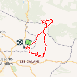
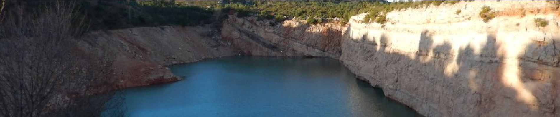
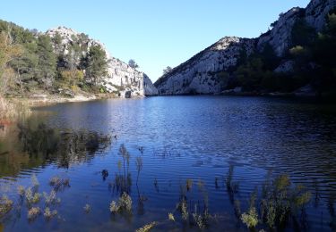
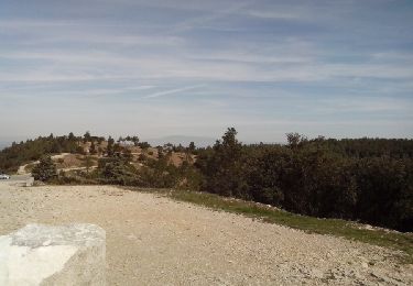
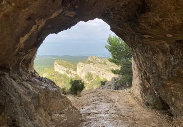
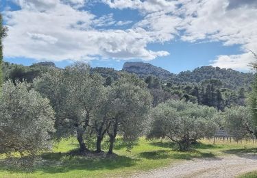
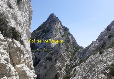
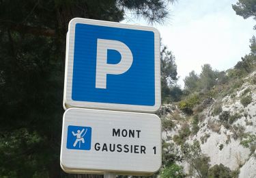
Randonnée dans un univers typique des Alpilles avec peu de végétation et des vues grandioses. Du parking de la carrière, aller chercher le chemin du Gaudre de Valoste, le quitter par la droite (chaine) et poursuivre le bon chemin pour arriver à la citerne des Amants sur une longue crête. Le sentier plonge très raide vers le fond de la combe, sur un bon chemin. Faire le tour de ce vallon "à la cale du plateau de Caume" pour retourner à la citerne. Revenir sur le chemin emprunté à l'arrivée sur 500m pour trouver un sentier à droite (cairn) qui se dirige vers la crête des Grands Calans et vous ramène progressivement au parking. Bonne rando.
Localisation
Commentaires
Randonnées à proximité
![Randonnée Marche Saint-Rémy-de-Provence - Alpilles - Photo](https://media.geolcdn.com/t/375/260/3d9065b1-8760-4c6a-ad48-7d20309ee04e.jpg&format=jpg&maxdim=2)
![Marche Marche](https://static1.geolcdn.com/sitytour/trail-icons/101.png)
Marche
![](/images/other/stat-length.png)
![](https://static1.geolcdn.com/siteimages/upload/files/16400158638029165_repeat_loop_refresh_sync_direction_icon.png)
![Randonnée Marche Saint-Rémy-de-Provence - Les Baux-Crêtes des Alpilles 11-03-17 - Photo](https://media.geolcdn.com/t/375/260/ext.jpg?maxdim=2&url=https%3A%2F%2Fservices.sitytrail.com%2FGeolivesWS%2FDownloadMedia.ashx%3FTrailID%3D830452%26Media%3Dfix__20170311124727.jpg)
![Marche Marche](https://static1.geolcdn.com/sitytour/trail-icons/101.png)
Marche
![](/images/other/stat-length.png)
![](https://static1.geolcdn.com/siteimages/upload/files/16400158638029165_repeat_loop_refresh_sync_direction_icon.png)
![Randonnée Marche Saint-Rémy-de-Provence - Les Alpilles pas de l aigle - Photo](https://media.geolcdn.com/t/375/260/ext.jpg?maxdim=2&url=https%3A%2F%2Fservices.sitytrail.com%2FGeolivesWS%2FDownloadMedia.ashx%3FTrailID%3D237633%26Media%3Dfix__20131215135904.jpg)
![Marche Marche](https://static1.geolcdn.com/sitytour/trail-icons/101.png)
Marche
![](/images/other/stat-length.png)
![](https://static1.geolcdn.com/siteimages/upload/files/16400158638029165_repeat_loop_refresh_sync_direction_icon.png)
![Randonnée Marche Saint-Rémy-de-Provence - Gaussier, Peiroou et les 2 trous - Photo](https://media.geolcdn.com/t/375/260/0e972cfb-a90b-436d-8a88-54242ee42a0b.jpg&format=jpg&maxdim=2)
![Marche Marche](https://static1.geolcdn.com/sitytour/trail-icons/101.png)
Marche
![](/images/other/stat-length.png)
![](https://static1.geolcdn.com/siteimages/upload/files/16400158638029165_repeat_loop_refresh_sync_direction_icon.png)
![Randonnée Marche Saint-Rémy-de-Provence - PF-Saint-Rémy-de-Provence - La Piste des Lombards - Photo](https://media.geolcdn.com/t/375/260/ext.jpg?maxdim=2&url=https%3A%2F%2Fstatic1.geolcdn.com%2Fsiteimages%2Fupload%2Ffiles%2F1553511878bg_sport_marche.png)
![Marche Marche](https://static1.geolcdn.com/sitytour/trail-icons/101.png)
Marche
![](/images/other/stat-length.png)
![](https://static1.geolcdn.com/siteimages/upload/files/16400158638029165_repeat_loop_refresh_sync_direction_icon.png)
![Randonnée Marche Saint-Rémy-de-Provence - PF-Saint Rémy de Provence - Lac du Peiroou - La Caume - RECO - Photo](https://media.geolcdn.com/t/375/260/f1baf7d8-6785-47be-a5c7-eeb027e98a93.jpg&format=jpg&maxdim=2)
![Marche Marche](https://static1.geolcdn.com/sitytour/trail-icons/101.png)
Marche
![](/images/other/stat-length.png)
![](https://static1.geolcdn.com/siteimages/upload/files/16400158638029165_repeat_loop_refresh_sync_direction_icon.png)
![Randonnée Marche Saint-Rémy-de-Provence - Crête des Alpilles (Rocher des 2 Trous) - Photo](https://media.geolcdn.com/t/375/260/f3551468-c9f1-4a2d-abbd-840da1fc657c.jpg&format=jpg&maxdim=2)
![Marche Marche](https://static1.geolcdn.com/sitytour/trail-icons/101.png)
Marche
![](/images/other/stat-length.png)
![](https://static1.geolcdn.com/siteimages/upload/files/16400158638029165_repeat_loop_refresh_sync_direction_icon.png)
![Randonnée Marche Les Baux-de-Provence - PF-Les Baux de Provence - Le Vallon des Amants par la piste des Lombards - DD - Photo](https://media.geolcdn.com/t/375/260/4167157d-ddfc-4521-a7e2-ea51daef36e9.jpg&format=jpg&maxdim=2)
![Marche Marche](https://static1.geolcdn.com/sitytour/trail-icons/101.png)
Marche
![](/images/other/stat-length.png)
![](https://static1.geolcdn.com/siteimages/upload/files/16400158638029165_repeat_loop_refresh_sync_direction_icon.png)
![Randonnée Marche Saint-Rémy-de-Provence - St rémy de Provence mont gaussien les 2 trous - Photo](https://media.geolcdn.com/t/375/260/04677b89-65c5-4427-9f2a-65d9705bc97c.jpg&format=jpg&maxdim=2)
![Marche Marche](https://static1.geolcdn.com/sitytour/trail-icons/101.png)
Marche
![](/images/other/stat-length.png)
![](https://static1.geolcdn.com/siteimages/upload/files/16400158638029165_repeat_loop_refresh_sync_direction_icon.png)